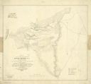
| Date: | 1865 |
|---|---|
| Description: | This map is a pen and ink tracing. Union positions are shown in blue and Confederate positions are shown in red. Roads, vegetation, and streams are labeled... |
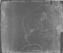
| Date: | 1900 |
|---|---|
| Description: | This map shows portion of the military road from Fond du Lac to the Wisconsin River near Fort Winnebago, with mile markers and adjacent land use. A few pro... |

| Date: | 04 1777 |
|---|---|
| Description: | Map showing the area from Newtown, Pennsylvania to Kingston, New Jersey, with routes and battles of British (red) and American forces (blue). The map inclu... |
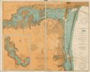
| Date: | 1908 |
|---|---|
| Description: | This map shows streets, industrial buildings, a portion of Lake Superior and other lakes, bays, and rivers in portions of Duluth and Superior. Relief is sh... |
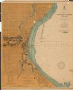
| Date: | 1907 |
|---|---|
| Description: | This map is a chart of Milwaukee Harbor that displays local streets, bridges, roads, railroads, public buildings, businesses, factories, dry docks, parks, ... |

| Date: | 1760 |
|---|---|
| Description: | Map of North America based upon the cartographic work of de L'Isle. It shows cities, regions, lakes, rivers, Native American land, mountains, islands, and ... |

| Date: | 02 1783 |
|---|---|
| Description: | Map of the United States and one of the first to show the new boundaries created by the Preliminary Treaty signed on January 20, 1783. The former colonies ... |
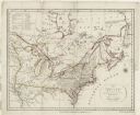
| Date: | 1792 |
|---|---|
| Description: | Map of the United States east of the Mississippi River and north of the Ohio River. It shows the borders between the north eastern states, Canada and the U... |

| Date: | 1780 |
|---|---|
| Description: | Detailed topographical and political map of the area from Lake Champlain to Albany and the Hudson River. Relief is shown through hachures. The map shows ci... |

| Date: | 10 1776 |
|---|---|
| Description: | Broadside map showing the British invasion of New York city in August and September of 1776. The map shows important cities, forts, roads, hills, mountains... |

| Date: | 1776 |
|---|---|
| Description: | Fairly detailed map of New York City and parts of Long Island. It shows streets, roads, wharves, ferries, ship yards, Fort George and the battery, public b... |

| Date: | 1941 |
|---|---|
| Description: | Hand-drawn, watercolor and ink, map of Lake Mendota. Locations and many small figures appear around the shore with explanations referring to Indian legends... |
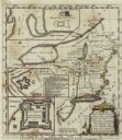
| Date: | 1755 |
|---|---|
| Description: | Map of New England, with three inset maps of Fort Oswego, Fort du Quesne, and Fort Frederick. It shows colonies, a few cities, forts (marked as French or E... |
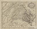
| Date: | 1762 |
|---|---|
| Description: | Map of Virginia and parts of Maryland. It shows borders, boundary lines, Native American tribes and land, towns, forts, roads, mountains, waterfalls, bays,... |

| Date: | 1839 |
|---|---|
| Description: | This map, one of a series made by Thomas Jefferson Cram of the U.S. Topographical Engineers from personal surveys, covers the area from Green Bay to the ju... |

| Date: | 1758 |
|---|---|
| Description: | This detailed map of north eastern America shows the boundaries, cities, mountains, rivers, lakes, Native American land and towns, and roads from east of t... |
If you didn't find the material you searched for, our Library Reference Staff can help.
Call our reference desk at 608-264-6535 or email us at: