 Search: grants
Filter: Year of 1800-1899
Search: grants
Filter: Year of 1800-1899

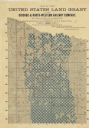
| Date: | 1886 |
|---|---|
| Description: | Wisconsin map showing land offices, railroads completed, railroad land grants and Indian reservations. |

| Date: | 1875 |
|---|---|
| Description: | A hand-drawn and colored map of Wisconsin showing the railroad routs and railroad land grants La Cross and Milwaukee Railroad, St. Croix and Tomah Railroad... |

| Date: | 1856 |
|---|---|
| Description: | A map showing rail lines in Wisconsin and the railroad land grants of the Superior & St. Croix Railroad in the present-day northwestern Wisconsin counties ... |
| Date: | 1888 |
|---|---|
| Description: | Map of northern Wisconsin showing the Chicago and North-Western Railway Company’s land grants within the counties of Forest, Florence, Langlade, Marinette,... |

| Date: | 1875 |
|---|---|
| Description: | This manuscript map shows the limits of the land grants made to railroads in northwestern Wisconsin along the corridor between Portage and Hudson, along th... |

| Date: | 1864 |
|---|---|
| Description: | A hand-colored survey map of southeastern Minnesota and Wisconsin, showing the locations of railroads, land grant railroads, land offices, and the 6 and 15... |

| Date: | 1880 |
|---|---|
| Description: | This map covers parts of Minnesota, Iowa, and South Dakota and advertised 1,000,000 acres of land available. Communities, roads, and railroad lines are lab... |

| Date: | 1896 |
|---|---|
| Description: | A map showing the Wisconsin Central Railroad lines in Wisconsin, northern Illinois, eastern Minnesota, and Michigan’s Upper Peninsula. The area of the map ... |
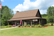
| Community: | Wabeno |
|---|---|
| County: | Forest |
| Historic Name: | CHICAGO AND NORTH-WESTERN LAND OFFICE |
| Reference Number: | 29119 |
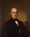
| Date: | 1862 |
|---|---|
| Description: | Portrait of the governor in the executive chamber. |

| Lawyer, Politician and Governor |
|---|
| Discover the history of Wisconsin governor Bashford Coles. |
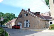
| Richland Center Depot, Richland Center, Wisconsin |
|---|
| A crumbling 1909 railroad depot is rehabilitated with help from federal grants. |
| Community: | Madison |
|---|---|
| County: | Dane |
| Historic Name: | Metal and Mining Engineering |
| Reference Number: | 101190 |
| Brief biography of fomer WI governor William Augustus Barstow (1813 - 1865). |
| A Dishonest Democrat and a Radical Republican |
|---|
| Learn about the election that was so close that Wisconsin briefly had two governors until one was exposed for tampering with ballots. |
| A Bizarre Story of Land Prospecting Gone Awry |
|---|
| Read the amazing story of a man who watched his potential 10,000-square-mile northern Wisconsin empire disappear into thin air. |

| Community: | Madison |
|---|---|
| County: | Dane |
| Historic Name: | H. Lavender and Pauline Farr House |
| Reference Number: | 112906 |
If you didn't find the material you searched for, our Library Reference Staff can help.
Call our reference desk at 608-264-6535 or email us at:
