 Search: increase
Search: lapham
Filter: Categories of Wisconsin Historical Images
Search: increase
Search: lapham
Filter: Categories of Wisconsin Historical Images
| Date: | 1869 |
|---|---|
| Description: | Carte-de-visite portrait of Robert von Schlagintweit (1833-1885), German orientalist, geographer and explorer. Along with his oldest brother Hermann, Rober... |
| Date: | 1869 |
|---|---|
| Description: | Carte-de-visite portrait photograph of Alexander Winchell (1824-1891), former state geologist of Michigan and professor of Geology and Paleontology at the ... |
| Date: | 1854 |
|---|---|
| Description: | Carte-de-visite portrait of John Lawrence Smith (1818-1883), American chemist. From 1846-1850, he worked for the Turkish government, exploring their count... |
| Date: | 1864 |
|---|---|
| Description: | Carte-de-visite portrait of Sir William Jackson Hooker (1785-1865), English botanist. Preceded his son, Joseph Dalton Hooker, as director of Kew Gardens. ... |
| Date: | 1864 |
|---|---|
| Description: | Carte-de-visite portrait of Josiah Hoopes (b. 1832, death date unknown), American botanist. In 1853, he established a tree nursery in West Chester, which i... |
| Date: | 1864 |
|---|---|
| Description: | Carte-de-visite portrait of Joshua Hoopes (1788-1874), American Botanist. An infant at the time of the Wyoming Indian massacre, his mother strapped him on ... |
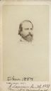
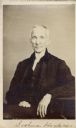
| Date: | 12 1864 |
|---|---|
| Description: | Vignetted carte-de-visite portrait of Dr. Henry Parker Sartwell (1792-1867), American botanist. |
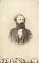
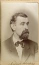
| Date: | 1869 |
|---|---|
| Description: | Vignetted carte-de-visite portrait of Edmund Andrews (1824-1904), Vermont-born surgeon. Andrews served as Professor of Comparative Anatomy at the Universit... |

| Date: | 1865 |
|---|---|
| Description: | Drawn the last year of the Civil War, this thematic map shows the effects that Lake Michigan has had on Wisconsin temperatures in January and July. The map... |
| Date: | 1848 |
|---|---|
| Description: | This map shows the township and range system in southern and eastern Wisconsin as well as along the Wisconsin River in present-day Marathon, Portage, and W... |

| Date: | 1844 |
|---|---|
| Description: | An ink on paper, hand-drawn map of Milwaukee County that shows the sectioning of townships, the boundary of the canal grant, roads, streams, lakes, includi... |

| Date: | 1830 |
|---|---|
| Description: | An ink on paper, hand-drawn map of the town of Milwaukee, showing the divisions and landownership within the town by private individuals as well as those l... |

| Date: | 1800 |
|---|---|
| Description: | This pen and ink drawing with watercolor shows the course of the Black River from Rock Creek, near Greenwood in Clark County, Wisconsin, to its confluence ... |

| Date: | 1868 |
|---|---|
| Description: | This map is ink on tracing cloth and shows lot and block numbers, depot, railroads and side tracks, and streets in sections 24 and 25, T.11, R.16E. The map... |

| Date: | 1855 |
|---|---|
| Description: | This map shows lot and block numbers, buildings, some landownership, roads, railroads, cemeteries, the Milwaukee River, and Lake Michigan. The map includes... |

| Date: | 1868 |
|---|---|
| Description: | This map shows lot and block numbers, some property ownership, wards, roads, and railroads. An inset map shows the Glidden & Lockwood’s addition. There are... |

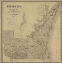
| Date: | 1845 |
|---|---|
| Description: | Map of Wisconsin, including lower western border with Iowa, southern border along Illinois, eastern shoreline of Lake Michigan, and northern area along Wis... |
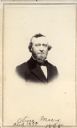
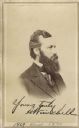
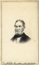
| Date: | 1865 |
|---|---|
| Description: | Carte-de-visite portrait of Oliver Marcy (1820-1899), American educator and natural scientist. In 1862, he became professor and chair of the natural histor... |
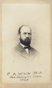
| Date: | 1868 |
|---|---|
| Description: | Carte-de-visite portrait of Charles A. White (1826-1910), an American geologist and paleontologist. White was the State geologist of Iowa in 1866-70, and a... |
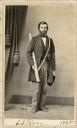
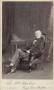
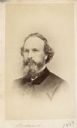
| Date: | 1865 |
|---|---|
| Description: | Full-length carte-de-visite portrait of Charles C. Parry (1823-1890), American Botanist. Parry is most famous for his botanical research in the southern Ro... |
If you didn't find the material you searched for, our Library Reference Staff can help.
Call our reference desk at 608-264-6535 or email us at: