 Search: indians
Search: menominee
Filter: Categories of Wisconsin Historical Images
Filter: Year of 1900-1999
Search: indians
Search: menominee
Filter: Categories of Wisconsin Historical Images
Filter: Year of 1900-1999

| Date: | 1956 |
|---|---|
| Description: | This map shows reservation boundaries, U.S. township lines, highways, roads, rivers, and lakes. The lower left corner of the map includes a legend of "Conv... |

| Date: | 1914 |
|---|---|
| Description: | This map shows township grids, railroads, roads, and drainage. The area of the map covers northeastern Wisconsin and Menominee Indian reservation. Green Ba... |
| Date: | 1953 |
|---|---|
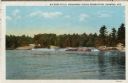
| Description: | View upriver across water towards the Big Eddy Falls on the Wolf River. A group of people are standing on the right bank. Caption reads: "Big Eddy Falls, M... |
| Date: | 05 25 1926 |
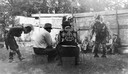
|---|---|
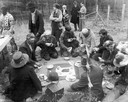
| Description: | Menominee Indians eating lunch together on Chief Oshkosh Day, May 25, 1926, "the occasion of the removal of the chief's remains from an unmarked grave besi... |

| Date: | 1909 |
|---|---|
| Description: | A Menominee child, probably photographed on the reservation near Keshena and Neopit, Wisconsin. He is standing outside in front of a log cabin, and an axe ... |
| Date: | 1929 |
|---|---|
| Description: | Map of the Menominee Indian Reservation. Legend reads: "Topographic and cultural data were obtained from field notes of a timber cruise and land classifica... |
| Date: | 1958 |
|---|---|
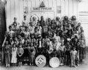
| Description: | Peavey Falls group of dancers and musicians from the Menominee Indian Reservation in Wisconsin. The group is standing in front of a building with a sign th... |

| Date: | 1936 |
|---|---|
| Description: | Loading a large white pine log cut on the Menominee Indian Reservation onto a truck. The log was hauled to the Wisconsin State Fair for a display about the... |
| Date: | 1936 |
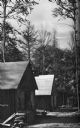
|---|---|
| Description: | Exterior view of a logging camp on the Menominee Indian Reservation. The three buildings are surrounded by forest. |

| Date: | 1952 |
|---|---|
| Description: | This map shows counties, towns, cities, and selected villages, as well as the Menominee Indian Reservation are identified on this U.S. Post Office. Circles... |
| Date: | 1903 |
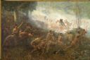
|---|---|
| Description: | An important event of the French and Indian War (1754-1763) was commissioned in 1903 by Robert Laird McCormick, president of the State Historical Society o... |
| Date: | 1942 |
|---|---|
| Description: | A Menominee ceremonial dance. The dancers are wearing Native American ceremonial dress. Although Roman Catholic missions had banned many Native American ce... |
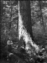
| Date: | 07 1936 |
|---|---|
| Description: | Ray Weber standing next to a large white pine on a Menominee Indian reservation. |
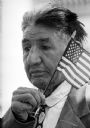
| Date: | 05 30 1961 |
|---|---|
| Description: | World War I veteran Edward J. Starr watches the Memorial Day service at the State Capitol while holding a small American flag. He is from a Menominee India... |
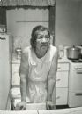
| Date: | 11 26 1970 |
|---|---|
| Description: | A candid portrait of Olivia King in her kitchen at their home on Rabbit Ridge on the Menominee reservation. |

| Date: | 1933 |
|---|---|
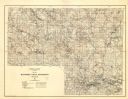
| Description: | This map shows the township and range system, sections, cities and villages, schools, roads, railroads, and lakes and streams in Shawano County, which at t... |

| Date: | 1930 |
|---|---|
| Description: | This map shows rivers, lakes, trails, Indian villages, distances, and boundaries of tracts ceded by the Munnomonee, Winnebaygoes, and New York Indians Trib... |

| Date: | 1902 |
|---|---|
| Description: | This map shows the railroads of southern Wisconsin with the routes of the Chicago, Milwaukee, and St. Paul Railway traced in red. The township grid, counti... |

| Date: | 1979 |
|---|---|
| Description: | A map of Southern Wisconsin and northern Illinois showing the areas inhabited by the Ho-Chuck, formerly known as the Winnebago. Some of the location names ... |
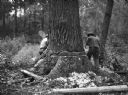
| Date: | 07 1936 |
|---|---|
| Description: | Two men are working together to cut down a large white pine tree on a Menominee Indian reservation. |
If you didn't find the material you searched for, our Library Reference Staff can help.
Call our reference desk at 608-264-6535 or email us at: