Search: indians
Search: menominee
Filter: Year of 1800-1899
Search: indians
Search: menominee
Filter: Year of 1800-1899
| Date: | 08 19 1825 |
|---|---|
| Description: | Third page of the Treaty between the United States and the Chippewa, Sauk, Fox, Menominee, Iowa, Sioux, Winnebago and a portion of the Ottawa, Chippewa, an... |
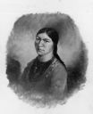
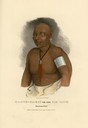
| Date: | 1845 |
|---|---|
| Description: | Menominee woman, Iwa-toke, "The Serpent," sister to Ke-wah-ten, "The North Wind." |
| Date: | 08 19 1825 |
|---|---|
| Description: | Second page of the Treaty between the United States and the Chippewa, Sauk, Fox, Menominee, Iowa, Sioux, Winnebago and a portion of the Ottawa, Chippewa, a... |
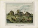
| Date: | 1842 |
|---|---|
| Description: | A Menominee village as depicted by Francois, Comte de Castelnau, a French naturalist and diplomat who visited the Green Bay area about 1838. The detailed, ... |

| Date: | 1860 |
|---|---|
| Description: | A survey map of Wisconsin, southeastern Minnesota, and northern Iowa, showing the status of surveys, rivers, and lakes. The map also shows the locations of... |

| Date: | 1835 |
|---|---|
| Description: | Ma-ko-me-ta or Bear's Oil, a Monomonie (Menominee) Chief. Hand-colored lithograph from the Aboriginal Portfolio, sketched at the treaty of Green Bay (1827)... |
| Date: | 1835 |
|---|---|
| Description: | Ma-che-ka-kat, or the Bad Hawk, a Chief of the Monomonie (Menominee) Tribe. Hand-colored lithograph from the Aboriginal Portfolio, painted at the Treaty of... |

| Date: | 10 21 1855 |
|---|---|
| Description: | Map of the Wisconsin and the Minnesota Territory showing the status of township surveys in Wisconsin and southeastern Minnesota. The Wisconsin reservation... |

| Date: | 1857 |
|---|---|
| Description: | A map of the state of Wisconsin and the southeastern portion of the Territory of Minnesota, showing the Wisconsin reservations of the Oneida, Menominee, St... |

| Date: | 1856 |
|---|---|
| Description: | This map of shows the township survey grid and identifies counties, named towns, cities and villages, rivers, lakes, railroads, roads, and the Menomonee an... |

| Date: | 1873 |
|---|---|
| Description: | This hand-colored map of Wisconsin depicts the township survey grid and identifies counties, named towns, cities and villages, rivers, lakes, railroads, an... |
| Date: | 08 19 1825 |
|---|---|
| Description: | Beginning page of the Treaty between the United States and the Chippewa, Sauk, Fox, Menominee, Iowa, Sioux, Winnebago and a portion of the Ottawa, Chippewa... |
| Date: | 08 19 1825 |
|---|---|
| Description: | Fourth page of the Treaty between the United States and the Chippewa, Sauk, Fox, Menominee, Iowa, Sioux, Winnebago and a portion of the Ottawa, Chippewa, a... |
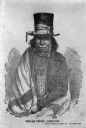
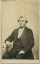
| Date: | 1850 |
|---|---|
| Description: | Drawing of Chief Oshkosh rendered from a daguerreotype by J.F. Harrison. He is wearing a top hat wrapped with a ribbon. Also a suitcoat, bowtie, beaded nec... |

| Date: | 1851 |
|---|---|
| Description: | A survey map of Wisconsin and eastern Minnesota, with the township surveys for portions of the Saint Croix region in progress. The maps also show the Meno... |

| Date: | 1835 |
|---|---|
| Description: | Little Lake Butte Des Morts just north of Lake Winnebago where Governor Lewis Cass of Michigan, and Thomas McKenney, head of the Bureau of Indian Affairs (... |

| Date: | 1858 |
|---|---|
| Description: | A survey map that shows the status of township surveys in Wisconsin. At that point, the majority of the state had been surveyed and platted, with the area... |

| Date: | 1846 |
|---|---|
| Description: | A map of Wisconsin and a portion of Minnesota that show the township surveys in progress in portions of the Saint Croix River region and in central Wiscons... |

| Date: | 1848 |
|---|---|
| Description: | Map of Wisconsin and a portion of Minnesota showing the township surveys in progress in portions of the Saint Croix River region and in central Wisconsin a... |
If you didn't find the material you searched for, our Library Reference Staff can help.
Call our reference desk at 608-264-6535 or email us at: