 Search: menominee
Filter: Subject of human settlements
Search: menominee
Filter: Subject of human settlements

| Date: | 1923 |
|---|---|
| Description: | This map shows the movement of iron ore in parts of Minnesota, Wisconsin, and the Upper Peninsula of Michigan, and includes parts of Lake Superior, Green B... |

| Date: | 1859 |
|---|---|
| Description: | This map of the entire state of Wisconsin depicts the township survey grid and identifies counties, named towns, cities and villages, rivers, lakes, railro... |

| Date: | 1882 |
|---|---|
| Description: | A hand-colored, sectional map of Wisconsin showing the township grid, completed and proposed railroads, counties, towns, cities, villages. The map also inc... |

| Date: | 1930 |
|---|---|
| Description: | This map shows rivers, lakes, trails, Indian villages, distances, and boundaries of tracts ceded by the Munnomonee, Winnebaygoes, and New York Indians Trib... |
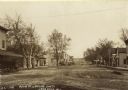
| Date: | 1909 |
|---|---|
| Description: | Text on front reads: "Main Street Looking South, Lone Rock, Wis." Unpaved street with sidewalks, dwellings and buildings on both sides. Horse drawn vehicle... |

| Date: | 1896 |
|---|---|
| Description: | This hand-colored map shows counties, county seats, cities, towns, proposed and completed railroads, and U.S. Land Offices. Also included in the map are th... |
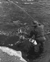
| Date: | 10 1962 |
|---|---|
| Description: | Elevated view of a fisherman netting his fish near the bridge at Keshena Falls. Caption on reverse reads: "This is an actual catch I just happened to be pr... |
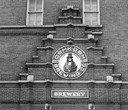
| Date: | |
|---|---|
| Description: | Sign above the main entrance of the Oshkosh Brewing Company, which uses an illustration of Chief Oshkosh as part of its logo. The sign was installed there... |

| Date: | 1856 |
|---|---|
| Description: | This map with an ornamental border shows the township survey grid and identifies counties, named towns, cities and villages, rivers, lakes, railroads, road... |

| Date: | 1846 |
|---|---|
| Description: | This map shows the plotting of the various townships in Wisconsin, both those that had been surveyed and some outlines for those which have not. A note in ... |
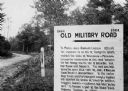
| Date: | 1923 |
|---|---|
| Description: | Old Military Road sign. Sign reads: "1864 — 1924 Old Military Road — In March — 1863 — Abraham Lincoln affixed his signature to an act of Congress which en... |

| Date: | 1910 |
|---|---|
| Description: | Text on front reads: "But you will not go astray if you go to the 'Palm Garden. F.J. Gaetzman, Wausau, Wis." A photo postcard with two images. On the left ... |
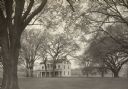
| Date: | 1951 |
|---|---|
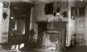
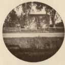
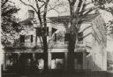
| Description: | The Grignon house was built (at the later address of 1313 Augustine Street) in 1836 by Charles Grignon. Charles Grignon was the son of Augustin Grignon, on... |
| Date: | 1948 |
|---|---|
| Description: | The Grignon house was built (at the later address of 1313 Augustine Street) in 1836 by Charles Grignon. Charles Grignon was the son of Augustin Grignon, on... |
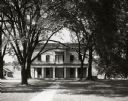
| Date: | 1945 |
|---|---|
| Description: | The Grignon house was built (at the later address of 1313 Augustine Street) in 1836 by Charles Grignon. Charles Grignon was the son of Augustin Grignon, on... |
| Date: | 1905 |
|---|---|
| Description: | The Grignon house was built (at the later address of 1313 Augustine Street) in 1836 by Charles Grignon. Charles Grignon was the son of Augustin Grignon, on... |
| Date: | 1930 |
|---|---|
| Description: | The Grignon house was built (at the later address of 1313 Augustine Street) in 1836 by Charles Grignon. Charles Grignon was the son of Augustin Grignon, on... |
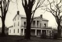
| Date: | 1890 |
|---|---|
| Description: | The Grignon house was built (at the later address of 1313 Augustine Street) in 1836 by Charles Grignon. Charles Grignon was the son of Augustin Grignon, on... |
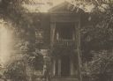
| Date: | 1881 |
|---|---|
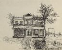
| Description: | Reproduction of a pen drawing of the Grignon house. The Grignon house was built (at the later address of 1313 Augustine Street) in 1836 by Charles Grignon.... |
| Date: | 1942 |
|---|---|
| Description: | The Grignon house was built (at the later address of 1313 Augustine Street) in 1836 by Charles Grignon. Charles Grignon was the son of Augustin Grignon, on... |
If you didn't find the material you searched for, our Library Reference Staff can help.
Call our reference desk at 608-264-6535 or email us at: