 Search: menominee
| Date: | 01 07 1855 |
|---|---|
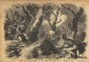
| Description: | Sketch of the defeat of General Braddock during an ambush in the French and Indian War. Caption reads: "Defeat of General Braddock, in the French and India... |

| Date: | 1859 |
|---|---|
| Description: | This map of the entire state of Wisconsin depicts the township survey grid and identifies counties, named towns, cities and villages, rivers, lakes, railro... |

| Date: | 1882 |
|---|---|
| Description: | A hand-colored, sectional map of Wisconsin showing the township grid, completed and proposed railroads, counties, towns, cities, villages. The map also inc... |
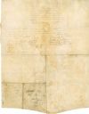
| Date: | 08 18 1821 |
|---|---|
| Description: | The reverse side of the Green Bay treaty, August 18, 1821. The treaty is signed by the chiefs of the six Indian nations for the possession of lands near th... |

| Date: | 1930 |
|---|---|
| Description: | This map shows rivers, lakes, trails, Indian villages, distances, and boundaries of tracts ceded by the Munnomonee, Winnebaygoes, and New York Indians Trib... |
| Community: | Marinette |
|---|---|
| County: | Marinette |
| Historic Name: | |
| Reference Number: | 23009 |
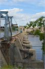
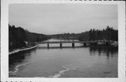
| Community: | Oshkosh |
|---|---|
| County: | Winnebago |
| Historic Name: | Cooper D. Wells Bridge |
| Reference Number: | 70836 |
| Community: | Wauwatosa |
|---|---|
| County: | Milwaukee |
| Historic Name: | CURRIE PARK CHEMICAL STORAGE SHED |
| Reference Number: | 233311 |
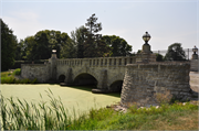
| Community: | Amberg |
|---|---|
| County: | Marinette |
| Historic Name: | CHALK HILL BRIDGE |
| Reference Number: | 44314 |
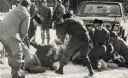
| Date: | 01 27 1975 |
|---|---|
| Description: | Members of the Wisconsin National Guard arrest a group of Native Americans during the takeover of the Alexian Brother Novitiate near Gresham. The arrest wa... |
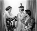
| Date: | 05 25 1956 |
|---|---|
| Description: | Attending the YWCA Benefit Tea for internationally speaking foreign students in costume of their native land are, left to right: Judith Ahana, Honolulu Haw... |
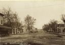
| Date: | 1909 |
|---|---|
| Description: | Text on front reads: "Main Street Looking South, Lone Rock, Wis." Unpaved street with sidewalks, dwellings and buildings on both sides. Horse drawn vehicle... |
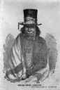
| Date: | 1850 |
|---|---|
| Description: | Drawing of Chief Oshkosh rendered from a daguerreotype by J.F. Harrison. He is wearing a top hat wrapped with a ribbon. Also a suitcoat, bowtie, beaded nec... |

| Discover historical details and explore our online collections related to Shawano, Wisconsin. |
| Community: | Beecher |
|---|---|
| County: | Marinette |
| Historic Name: | MISCAUNO ISLAND W&M RR PRATT HALF-HIP PONY TRUSS BRIDGE |
| Reference Number: | 22687 |
If you didn't find the material you searched for, our Library Reference Staff can help.
Call our reference desk at 608-264-6535 or email us at: