 Search: public
Filter: Subject of islands
Search: public
Filter: Subject of islands

| Date: | 1872 |
|---|---|
| Description: | Birds-eye drawing of Eau Claire depicts street names and street locations, houses, trees, bridges, piers, canals, railroads, and the Chippewa and Eau Clair... |

| Date: | 1890 |
|---|---|
| Description: | Shows plat of town, local streets, steam boat landings, and Chippewa River. Public square and Muskoo Island hand-colored. Map reads: "Full Lots are 125x66 ... |
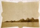
| Date: | 1910 |
|---|---|
| Description: | Lakeside view of Nebraska Row, showing Treaty Hall, La Pointe, Madeline Island. |

| Date: | 1836 |
|---|---|
| Description: | This is a cadastral map and shows proposed lot and block numbers for a paper city on the banks of the Rock River. Also shown are two public squares and som... |
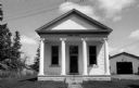
| Date: | 05 16 1973 |
|---|---|
| Description: | Front view of the La Pointe Town Hall on Madeline Island. |

| Date: | 1910 |
|---|---|
| Description: | Doty's Loggery. Caption printed under image reads: "Governor James Duane Doty, in 1845, built this log house on Doty's Island (Menasha), and resided there ... |

| Date: | 1910 |
|---|---|
| Description: | Bird's-eye view looking east, with Washburn Harbor at center and Chequamegon Bay in Lake Superior covering most of the upper image. Streets with buildings... |

| Date: | |
|---|---|
| Description: | A bathing beach on an island near a bridge, with people in the water and on the beach within an enclosed area. A canoe and rowboat are pulled up on the sho... |

| Date: | |
|---|---|
| Description: | Aerial view of Potawatomi State Park, with the Sturgeon Bay shoreline in the background. |

| Date: | 1857 |
|---|---|
| Description: | This map shows section corners, quarter section corners, foundry, steam saw mill, steam grist mill, planning mill, court house, baptist church, congregatio... |

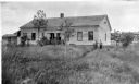
| Date: | |
|---|---|
| Description: | A group participating in the Citizenship group standing in front of Morning Star Hall, Johns Island. Charleston Evening Post and New Courier image. |

| Date: | 1902 |
|---|---|
| Description: | This map is a chart of Milwaukee Harbor that displays local streets, bridges, roads, railroads, public buildings, businesses, factories, dry docks, parks, ... |
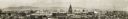
| Date: | 10 20 1914 |
|---|---|
| Description: | Elevated, panoramic view of the Panama-Pacific Exposition Grounds. Numbers across bottom of image refer to a key affixed to the image. Central building s... |

| Date: | 1859 |
|---|---|
| Description: | This map show plats including plat names, plat numbers, and some lot owner's names. Relief is shown by hachures. The map includes line drawings of Juneau B... |
| Date: | 1910 |
|---|---|
| Description: | George F. Thomas is holding a child and standing next to Edward F. Hansen in front of Treaty Hall in La Pointe on Madeline Island. |

| Date: | 1989 |
|---|---|
| Description: | This color coded map shows the various rivers, lakes, bays, and islands that make up the harbor. It includes an index of industries (maritime and non-marit... |

| Date: | 1831 |
|---|---|
| Description: | Map of the city of Louisville, Kentucky on the Ohio River showing streets and numbered lots. The Ohio River, Corn Island, and the Louisville and Portland C... |
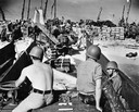
| Date: | 1944 |
|---|---|
| Description: | Soldiers, supplies and an International TD-9 diesel crawler tractor (TracTracTor) on a beach at Eniwetok Atoll in the Marshall Islands during World War II.... |

| Date: | 1911 |
|---|---|
| Description: | View down trail towards a small group of women and girls hiking in Cathedral Woods on a sunny day. The old growth forest is made up of pines and hemlocks. |

| Date: | 1911 |
|---|---|
| Description: | View down the first part of the path to Cathedral Woods from Barn Pond. The logs laid lengthwise and crosswise help one across the bog into the forest prop... |
If you didn't find the material you searched for, our Library Reference Staff can help.
Call our reference desk at 608-264-6535 or email us at: