 Filter: Categories of Wisconsin Historical Images
Filter: FORMAT_TYPE of prints, photomechanical
Filter: Subject of military art and science
Filter: Subject of lakes
Filter: Categories of Wisconsin Historical Images
Filter: FORMAT_TYPE of prints, photomechanical
Filter: Subject of military art and science
Filter: Subject of lakes

| Date: | 1835 |
|---|---|
| Description: | Little Lake Butte Des Morts just north of Lake Winnebago where Governor Lewis Cass of Michigan, and Thomas McKenney, head of the Bureau of Indian Affairs (... |

| Date: | 1862 |
|---|---|
| Description: | Lithography of C. Van Benthuysen. |
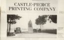
| Date: | 1915 |
|---|---|
| Description: | Advertisement with the Carl Schurz monument. Caption reads: "Castle-Pierce Printing Company, Aug. 1915", and at bottom: "Oshkosh, Wisconsin". Text on right... |
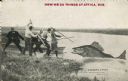
| Date: | 1910 |
|---|---|
| Description: | A group of men on a lakeshore grapple with a giant pike. Two men pull on a rope hooked to the pike while two more stand ready with harpoon-like sticks. Ano... |

| Date: | 1855 |
|---|---|
| Description: | Map reads "Our Country" which is accompanied by a sailor with a flag to the left and workers rejoicing under the Constitution and Laws to the right. Across... |

| Date: | 1905 |
|---|---|
| Description: | Lake near the home, probably Lake Hincks, which was named after General Edward W. Hincks who was administrator of the Home in the 1870's. The grounds consi... |

| Date: | 1876 |
|---|---|
| Description: | Map of home and land, with the roads, lakes, railroad, and buildings. |

| Date: | 1942 |
|---|---|
| Description: | Holiday card showing Navy Pier in Chicago. There is snow on the ground, the lake is frozen and two lines of planes are flying overhead forming a "V" patter... |

| Date: | 1941 |
|---|---|
| Description: | This pictorial map of Wisconsin with historical text highlights the history of the state and identifies places of interest, Indian villages, missions, trad... |

| Date: | 1846 |
|---|---|
| Description: | A hand-colored map of Wisconsin shows the counties in the state south and east of the Wisconsin and Fox rivers and the locations of Indian lands to the nor... |

| Date: | 1850 |
|---|---|
| Description: | A hand-colored map showing portions of present-day Iron and Vilas counties north of the Manitowish River as part of the Upper Peninsula of Michigan. The Wi... |

| Date: | 1852 |
|---|---|
| Description: | A hand-colored map showing portions of present-day Iron and Vilas counties north of the Manitowish River as part of the Upper Peninsula of Michigan. The Wi... |

| Date: | 1862 |
|---|---|
| Description: | This map of the southeastern United States shows cities and towns, rail lines, and geographic features such as rivers, mountains, lakes, and swamps. |

| Date: | 1864 |
|---|---|
| Description: | This colored map of the southern and eastern states shows locations of battles and skirmishes from 1861 through May 1864 with red dots or red underlining o... |
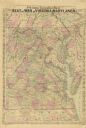
| Date: | 1865 |
|---|---|
| Description: | A general map of eastern Virginia, Maryland, Delaware, southern Pennsylvania, and northern North Carolina. |

| Date: | 1860 |
|---|---|
| Description: | A survey map of Wisconsin, southeastern Minnesota, and northern Iowa, showing the status of surveys, rivers, and lakes. The map also shows the locations of... |

| Date: | 1931 |
|---|---|
| Description: | This U.S. Geological Survey map of Wisconsin shows counties, cities and villages, lighthouses, Indian reservations, military reservations, and bird and gam... |

| Date: | 1912 |
|---|---|
| Description: | This map from the U.S. General Land Office shows railroads, counties, cities and villages, rivers, lakes, U.S. Land Offices, Indian reservations, military ... |

| Date: | 1931 |
|---|---|
| Description: | A topographical map from the U.S. Army Corp of Engineers showing the topography and man-made features in the Camp Williams area of the towns of Orange and ... |

| Date: | 1887 |
|---|---|
| Description: | This 1887 manuscript map by Amidon G. Miller covers portions of the towns of Nelson and Stockholm in Pepin County, Wisconsin, as well as a portion of the T... |
If you didn't find the material you searched for, our Library Reference Staff can help.
Call our reference desk at 608-264-6535 or email us at: