 Filter: Categories of Wisconsin Historical Images
Filter: Subject of Exploration
Filter: Type of Map or Atlas
Filter: Categories of Wisconsin Historical Images
Filter: Subject of Exploration
Filter: Type of Map or Atlas

| Date: | 1823 |
|---|---|
| Description: | In 1823 U.S. Army major Stephen H. Long led an expedition of scientific, trade, and military investigation up the Mississippi River and the Red River of th... |

| Date: | 1855 |
|---|---|
| Description: | Map reads "Our Country" which is accompanied by a sailor with a flag to the left and workers rejoicing under the Constitution and Laws to the right. Across... |
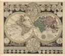
| Date: | 1745 |
|---|---|
| Description: | A two page world map featuring the Eastern and Western Hemispheres, as well as the northern and southern zodiacs. Additionally, the map is ordained with n... |

| Date: | 1836 |
|---|---|
| Description: | This map depicts Wisconsin and Michigan territories in 1836. It includes the area from Michigan to the Missouri River and Lake Winnipeg, and it shows the e... |

| Date: | 1761 |
|---|---|
| Description: | This map shows the western hemisphere. Much of the north-west coast of North America is left blank, but the rest of the map lists the names of rivers, citi... |

| Date: | 1790 |
|---|---|
| Description: | An updated and corrected version of Robert de Vaugondy's 1750 map "Amérique Septentrionale: Dressée sur les Relations les Plus Modernes des Voyageurs et Na... |

| Date: | 1783 |
|---|---|
| Description: | This map is hand-colored and shows the boundaries of British, Spanish, and the newly recognized American claims, as well as the fishing rights granted to F... |

| Date: | 1676 |
|---|---|
| Description: | Detailed map of North and South America. Cities, towns, forests, and mountains are shown pictorially. Duval labels regions, islands, cities, lakes, and Nat... |

| Date: | 1724 |
|---|---|
| Description: | Map showing the mountains, rivers, lakes, settlements, islands, and regions of North and South America. Characteristic of de L'Isle, this map is highly det... |

| Date: | 1746 |
|---|---|
| Description: | Detailed map of the western hemisphere and part of Africa and Europe. Islands, cities, settlements, rivers, lakes, countries, and regions are marked. Mount... |

| Date: | 1766 |
|---|---|
| Description: | This map of North America shows the boundaries of European claims at the end of the French and Indian war. The British colonies extend to the Mississippi. ... |

| Date: | 1770 |
|---|---|
| Description: | Map of North America showing the boundaries between French, Spanish, and English claims after the French and Indian War. Kitchin includes numerous place na... |

| Date: | 1720 |
|---|---|
| Description: | Map of North America from from the Rio Grande to the Atlantic Ocean, showing boundaries, the colonies, cities, settlements, mines, forts, Native American l... |
If you didn't find the material you searched for, our Library Reference Staff can help.
Call our reference desk at 608-264-6535 or email us at: