 Filter: Categories of Wisconsin Historical Images
Filter: Subject of Fortification
Filter: Subject of land
Filter: Categories of Wisconsin Historical Images
Filter: Subject of Fortification
Filter: Subject of land

| Date: | 1778 |
|---|---|
| Description: | Map of the land between Fort Ticonderoga and Albany. It shows cities, forts, mills, roads, mountains, swamps, waterfalls, lakes, and rivers. A few annotati... |

| Date: | 10 1776 |
|---|---|
| Description: | Broadside map showing the British invasion of New York city in August and September of 1776. The map shows important cities, forts, roads, hills, mountains... |

| Date: | 02 1777 |
|---|---|
| Description: | Map depicting the campaigns of October and November 1776, in Manhattan, Westchester, and part of New Jersey, published only a few months after the conclusi... |

| Date: | 03 1777 |
|---|---|
| Description: | Map showing the British and Hessian attack on Fort Washington in November of 1776. The movements and fortifications of the British and Hessian troops appea... |

| Date: | 11 1781 |
|---|---|
| Description: | Map of New York, Staten Island, and Long Island, showing the placements of forts, and the movement of troops in 1776. The map also includes towns, cities, ... |

| Date: | 1776 |
|---|---|
| Description: | Fairly detailed map of New York City and parts of Long Island. It shows streets, roads, wharves, ferries, ship yards, Fort George and the battery, public b... |

| Date: | 04 1777 |
|---|---|
| Description: | Map showing the area from Newtown, Pennsylvania to Kingston, New Jersey, with routes and battles of British (red) and American forces (blue). The map inclu... |

| Date: | 1781 |
|---|---|
| Description: | Map of the southern portion of the Chesapeake Bay and surrounding lands. It shows counties, a few cities and towns, forts, roads, islands, topographical fe... |

| Date: | 1791 |
|---|---|
| Description: | Small map of an abandoned Native American town and fort at the junction of the Ohio and Muskingum River. It shows the fortifications, an outline of the tow... |

| Date: | |
|---|---|
| Description: | A man is sitting on a horse in front of the cast and crew of the film "The Adventures of Marco Polo." Mountains are in the background. |

| Date: | |
|---|---|
| Description: | Cast members of the film "The Adventures of Marco Polo" standing in the entryway of a fortress. Marco Polo (Gary Cooper) is holding the hand of Binguccio (... |

| Date: | 04 18 1888 |
|---|---|
| Description: | A stereograph of ruins of a fireplace in an old French fort on the banks of the Mississippi River. The fort may have been built by Nicholas Perrot. |
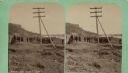
| Date: | 04 18 1888 |
|---|---|
| Description: | Stereograph of fireplace ruins on the site of an old French fort, possibly built by Nicholas Perrot. There is an electric pole behind the fireplace and a g... |

| Date: | 1915 |
|---|---|
| Description: | Austrian artillerymen taking a break from the battle at a firing position on the southwestern battlefront in Tyrol. Some of the men are smoking. The troops... |

| Date: | 1915 |
|---|---|
| Description: | Austrian soldiers post in front of the bunkers on the Italian front in the battle zone around Lavarone in South Tyrol. These are camouflaged artillery posi... |

| Date: | 1914 |
|---|---|
| Description: | Searchlight positioned on a fort in Antwerp in order to light a section of railroad track. Water is in the foreground. |

| Date: | |
|---|---|
| Description: | Mortar camouflaged against aerial observation. The camouflage has been prepared so carefully that one could walk by the piece at a short distance without n... |

| Date: | |
|---|---|
| Description: | Blocking a road with Spanish Rider obstacles on the southwestern battlefront. |

| Date: | |
|---|---|
| Description: | Tiroler Landesschuetzen (territorial troops from the Province of Tyrol) passing through a barricade in the mountains in preparation for a nighttime patrol... |
If you didn't find the material you searched for, our Library Reference Staff can help.
Call our reference desk at 608-264-6535 or email us at:
