 Filter: Categories of Wisconsin Historical Images
Filter: Subject of Military bases
Filter: Subject of hills
Filter: Categories of Wisconsin Historical Images
Filter: Subject of Military bases
Filter: Subject of hills

| Date: | 1840 |
|---|---|
| Description: | A view of Fort Crawford (the second site and buildings of 1829-?). |

| Date: | 1829 |
|---|---|
| Description: | Fort Crawford, from a sketchbook attributed to Seth Eastman, 1808-1875. A graduate of West Point, Eastman briefly served at Fort Crawford, 1829-1839. |

| Date: | 1831 |
|---|---|
| Description: | Fort Winnebago, a print published in Mrs. John H. Kinzie's Wau-bun (1856). |
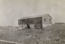
| Date: | 1898 |
|---|---|
| Description: | Ruins of the commissary warehouse at Fort Winnebago, about 1898. Fort Winnebago was closed in 1845 and the land and buildings sold. Today, only the Surgeon... |
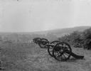
| Date: | |
|---|---|
| Description: | A view of Lunette Batteries. Canons stand in a line and United States flags are lined up into the distance. |

| Date: | 1917 |
|---|---|
| Description: | Panoramic group portrait of the Wisconsin National Guard Ambulance Company No. 1 at Camp Douglas, together with its ambulances and motorcycles with sidecar... |
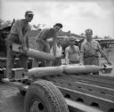
| Date: | 11 30 1943 |
|---|---|
| Description: | Michigan soldiers loading bombs onto a trailer at a military base near Port Moresby, New Guinea (present day Papua New Guinea). Their names, left to right,... |
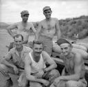
| Date: | 11 30 1943 |
|---|---|
| Description: | Michigan soldiers pose in front of a trailer loaded with bombs at a military base near Port Moresby, New Guinea (present day Papua New Guinea). Their names... |
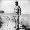
| Date: | 12 18 1943 |
|---|---|
| Description: | Robert Doyle's caption that accompanied this image reads, "Lieutenant Colonel Philip F. La Follette, three times Governor of Wisconsin, poses in combat uni... |

| Date: | 02 05 1944 |
|---|---|
| Description: | General view of Port Moresby Harbor from road, New Guinea (present day Papua New Guinea). A jeep is on the road on the left. Several soldiers are near a sh... |
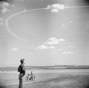
| Date: | 06 25 1944 |
|---|---|
| Description: | Major Daniel M. Lewis looks up at aircraft contrails at Royal Air Force station Steeple Morden, located 3.5 miles west of Royston, Hertfordshire, England. ... |
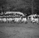
| Date: | 02 28 1945 |
|---|---|
| Description: | Robert Doyle wrote a caption for this image although it was not published at that time, "Fita Fita guard turns out daily at 8:00 a.m. for color raising cer... |
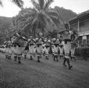
| Date: | 02 28 1945 |
|---|---|
| Description: | Robert Doyle wrote a caption for this image although it was not published at that time, "Fita Fita guard turns out daily at 8:00 a.m. for color raising cer... |

| Date: | 11 1960 |
|---|---|
| Description: | View from side of road of a helicopter flying low over a hilly rural road with grass, wildflowers and trees at Guantanamo, Cuba. A chain link fence topped ... |
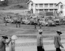
| Date: | 1967 |
|---|---|
| Description: | Men are walking in the foreground. In the background more men, in uniform, stand near several International Payscrapers parked in Phan Rang, Vietnam. Recen... |

| Date: | 1780 |
|---|---|
| Description: | Detailed topographical and political map of the area from Lake Champlain to Albany and the Hudson River. Relief is shown through hachures. The map shows ci... |

| Date: | 10 1776 |
|---|---|
| Description: | Broadside map showing the British invasion of New York city in August and September of 1776. The map shows important cities, forts, roads, hills, mountains... |

| Date: | 02 1777 |
|---|---|
| Description: | Map depicting the campaigns of October and November 1776, in Manhattan, Westchester, and part of New Jersey, published only a few months after the conclusi... |

| Date: | 03 1777 |
|---|---|
| Description: | Map showing the British and Hessian attack on Fort Washington in November of 1776. The movements and fortifications of the British and Hessian troops appea... |
If you didn't find the material you searched for, our Library Reference Staff can help.
Call our reference desk at 608-264-6535 or email us at:
