 Filter: Categories of Wisconsin Historical Images
Filter: Subject of Mountains
Filter: Subject of water
Filter: Categories of Wisconsin Historical Images
Filter: Subject of Mountains
Filter: Subject of water

| Date: | 1978 |
|---|---|
| Description: | Low-angle view from front driver's side tire of a red and white Scout being driven through a rocky stream. Mountains are in the background. |
| Date: | |
|---|---|
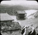
| Description: | View of a mountaintop house and other buildings with sod roofs. Two women, who are possibly Swiss or Norwegian, are in the foreground sitting on a steep hi... |
| Date: | |
|---|---|
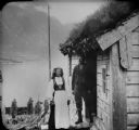
| Description: | A farming couple pose together on the steps of a building with a sod roof in Nordfjord country. In the background is a lake and a mountain on the far shore... |

| Date: | 1910 |
|---|---|
| Description: | View of Table Mountain and beach from Milnerton, South Africa. People are walking on the beach. |

| Date: | 1965 |
|---|---|
| Description: | Bodies of several dead Viet Cong soldiers lying on a beach. Several U.S. soldiers observe as bodies are placed in the sand from a truck. |

| Date: | 1895 |
|---|---|
| Description: | Map showing the continents of the world with the Americas at the center. From left to right land masses names are: "Siberia, Chinese Empire, Australia, Nor... |

| Date: | 1949 |
|---|---|
| Description: | This pictorial map shows the United States west of the Mississippi, including Indian Tribes, historic trails, forts, trading posts, mountain ranges, lakes ... |

| Date: | 1761 |
|---|---|
| Description: | This map shows the western hemisphere. Much of the north-west coast of North America is left blank, but the rest of the map lists the names of rivers, citi... |

| Date: | 1746 |
|---|---|
| Description: | Map of North America from the southern portion of James Bay to Florida. It shows the colonies, cities, Native American land, and topological and geographic... |

| Date: | 1758 |
|---|---|
| Description: | This map of the north-west hemisphere shows the cities, lakes, rivers, mountains, and political borders. In the upper left corner sits a decorative cartouc... |

| Date: | 1755 |
|---|---|
| Description: | This map shows forts, missions, villages and cities, rivers and portages, and boundaries of the Spanish, English, and French territories, marking the large... |

| Date: | 1757 |
|---|---|
| Description: | This map shows the cities, plantations, lakes, rivers, mountains, Native American territories and colonial borders of the Eastern half of North America, pl... |

| Date: | 1755 |
|---|---|
| Description: | This map shows the eastern half of North America during the French and Indian war, including cities, borders, Native American Land, forts, and detailed geo... |

| Date: | 1775 |
|---|---|
| Description: | This map shows the northern Pacific Ocean along with north eastern Asia and western North America. The interior of Asia contains detailed engravings of pla... |

| Date: | 1776 |
|---|---|
| Description: | This was one of the first maps available for the general British populace featuring America during the Revolutionary War. It includes forts, cities, topogr... |

| Date: | 1782 |
|---|---|
| Description: | Map of the West Indies and south eastern North America, remarkably detailed, showing cities, mountains, rivers, lakes, mines, plantations, forts, banks, an... |

| Date: | 1791 |
|---|---|
| Description: | An English and updated version of d'Anville's 1746 map "Amérique Septentrionale Publiée sous les Auspices de Monseigneur le Duc d'Orleans Prémier Prince du... |

| Date: | 1696 |
|---|---|
| Description: | This sea chart and topographical map depicts the north east coast of Canada and North America, focusing on the Hudson Bay and Great Lakes regions. It shows... |

| Date: | 1783 |
|---|---|
| Description: | This map is hand-colored and shows the boundaries of British, Spanish, and the newly recognized American claims, as well as the fishing rights granted to F... |

| Date: | 1758 |
|---|---|
| Description: | This detailed map of north eastern America shows the boundaries, cities, mountains, rivers, lakes, Native American land and towns, and roads from east of t... |
If you didn't find the material you searched for, our Library Reference Staff can help.
Call our reference desk at 608-264-6535 or email us at: