 Filter: Categories of Wisconsin Historical Images
Filter: Subject of Periodicals
Filter: Subject of arts
Filter: Subject of military art and science
Filter: Categories of Wisconsin Historical Images
Filter: Subject of Periodicals
Filter: Subject of arts
Filter: Subject of military art and science
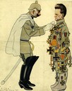
| Date: | 12 13 1917 |
|---|---|
| Description: | A color cartoon depicting Robert M. La Follette, Sr. as pro-German, showing Kaiser pinning medals on him. |
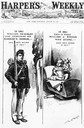
| Date: | 08 29 1896 |
|---|---|
| Description: | Cover of Harper's Weekly, with a pro-William McKinley Presidential cartoon depicting McKinley as a soldier in 1861 and William Jennings Bryan as an ... |

| Date: | 10 1951 |
|---|---|
| Description: | Photograph of a framed painting by Ben Stahl titled "Corporal Red Cloud's Last Stand." It was painted especially for "Esquire" magazine and honored Mitchel... |

| Date: | 04 19 1942 |
|---|---|
| Description: | Magazine clipping featuring Ronald Reagan in his army uniform prior to reporting for active duty in 1942. |

| Date: | 1758 |
|---|---|
| Description: | Map showing lakes, rivers, cities, Native American land, and the boundaries of French and English claims in America and Canada north of New York. A title c... |

| Date: | 1776 |
|---|---|
| Description: | Map of the American colonies and land east of the Mississippi River. Prominent cities, forts, Native American land, mountains, rivers and lakes are all sho... |

| Date: | 02 1783 |
|---|---|
| Description: | Map of the United States and one of the first to show the new boundaries created by the Preliminary Treaty signed on January 20, 1783. The former colonies ... |

| Date: | 1755 |
|---|---|
| Description: | Map of New England, with three inset maps of Fort Oswego, Fort du Quesne, and Fort Frederick. It shows colonies, a few cities, forts (marked as French or E... |

| Date: | 1775 |
|---|---|
| Description: | Map of Boston and surrounding regions, from Massachusetts Bay to the Connecticut River, and including part of southern New Hampshire. It shows the colonies... |

| Date: | 1762 |
|---|---|
| Description: | Map of Virginia and parts of Maryland. It shows borders, boundary lines, Native American tribes and land, towns, forts, roads, mountains, waterfalls, bays,... |

| Date: | 1781 |
|---|---|
| Description: | Map of the southern portion of the Chesapeake Bay and surrounding lands. It shows counties, a few cities and towns, forts, roads, islands, topographical fe... |

| Date: | 1760 |
|---|---|
| Description: | Map showing the towns, mountains, valleys, corn fields, and rivers of a portion of the Cherokee Nation. A few annotations on the map explain the land and r... |

| Date: | 1781 |
|---|---|
| Description: | Map of the British territory of West Florida, extending from the Mississippi River to the Apalachicola River. It shows the borders, cities, towns, forts, h... |

| Date: | 01 02 1962 |
|---|---|
| Description: | Portrait of Charles & Victoria Slayton, parents of astronaut Donald "Deke" Slayton, sitting in their home in Leon, Wisconsin with framed photographs of the... |

| Date: | 1936 |
|---|---|
| Description: | Reprint of caricatures from various publications. There are eight panels depicting the Spanish Civil War from publications such as "L'Œuvre," "El Noticiero... |

| Date: | 1936 |
|---|---|
| Description: | "La caricatura y la guerra. Graphic supplement to the «Servicio Español de Información»." Reprint of caricatures from various publications. There are seve... |
If you didn't find the material you searched for, our Library Reference Staff can help.
Call our reference desk at 608-264-6535 or email us at: