Visit our other Wisconsin Historical Society websites!
 Filter: Categories of Wisconsin Historical Images
Filter: Subject of Water
Filter: Subject of water
Filter: Subject of roads
Filter: Categories of Wisconsin Historical Images
Filter: Subject of Water
Filter: Subject of water
Filter: Subject of roads
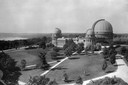
| Date: | 1935 |
|---|---|
| Description: | Elevated exterior view of Yerkes Observatory. Geneva Lake is in the background, left. Roads and sidewalks cross the sweeping, well tended lawns. The desi... |

| Date: | 1936 |
|---|---|
| Description: | This map is red and black ink on tracing cloth and is oriented with north to the upper left. This hand-drawn map shows a central portion of the military ro... |

| Date: | 1898 |
|---|---|
| Description: | Horse-drawn carriage stuck in a rut on a muddy road near the Ohio River in Floyd County, Indiana. One man is holding the horse while another attempts to di... |
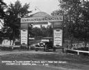
| Date: | 07 1927 |
|---|---|
| Description: | Car parked underneath the entrance gate to the Island Resort at the Wisconsin Dells, 25 miles from the Dells on Highway 12-16 near Mauston. Entrance gate a... |
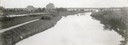
| Date: | 1908 |
|---|---|
| Description: | The Yahara River from Williamson Street with Lake Monona in the background. House & Barn pictured is located at 601 Riverside Drive. |

| Date: | 1870 |
|---|---|
| Description: | This bird's-eye-view map shows roads, a river with boats, and homes. The bottom margin of the map includes an index. |

| Date: | 1910 |
|---|---|
| Description: | View of La Pointe taken from Big Bay Road on Madeline Island. |

| Date: | 1886 |
|---|---|
| Description: | Bird's-eye view of Ashland, on the shores of Lake Superior, with insets of The Apostle Islands Chequamagon Bay & Ashland, and Distances from Ashland. |

| Date: | 1874 |
|---|---|
| Description: | This map shows lakes, rivers, state, county, and town boundaries, as well as railroads completed, in progress, and contemplated. The map includes a color d... |

| Date: | 1908 |
|---|---|
| Description: | A panoramic aerial view of the Isthmus taken from a kite. Lake Mendota is to the right in the background with Picnic Point jutting into the lake. The photo... |
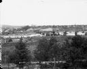
| Date: | |
|---|---|
| Description: | Elevated view from south side of the Chippewa River, with a bridge crossing it and buildings on both sides of the river. A bluff rises on the far side of t... |

| Date: | 06 07 1954 |
|---|---|
| Description: | Aerial view looking north from near the city's southwestern limits in 1954. Shows text indicating Midvale Boulevard, Odana Road, Tokay Boulevard, Mineral P... |

| Date: | 1873 |
|---|---|
| Description: | Map of the township of Windsor, from the "Atlas of Dane County." |

| Date: | 1964 |
|---|---|
| Description: | Aerial view of the Milwaukee County Zoo grounds nearing its completion. |

| Date: | 1856 |
|---|---|
| Description: | View looking west from Lake Michigan with several steam ships and sailing vessels in harbor. There is a lighthouse to left of center, along shoreline. |

| Date: | 1891 |
|---|---|
| Description: | Bird's-eye map of Wausau, looking north with ninety-eight businesses, industries, churches, schools, and civic buildings identified in location key below i... |

| Date: | 1886 |
|---|---|
| Description: | Bird's-eye view of Bayfield, county seat of Bayfield County. On the lower left side is an inset for Bayfield and the Apostle Islands. |

| Date: | 1853 |
|---|---|
| Description: | Bird's-eye map of Milwaukee looking east toward Lake Michigan from a bluff, long since graded into a slope, at about 6th Street between Wisconsin Avenue an... |
If you didn't find the material you searched for, our Library Reference Staff can help.
Call our reference desk at 608-264-6535 or email us at:

