 Filter: Categories of Wisconsin Historical Images
Filter: Subject of political science
Filter: Type of Map or Atlas
Filter: Categories of Wisconsin Historical Images
Filter: Subject of political science
Filter: Type of Map or Atlas

| Date: | 1965 |
|---|---|
| Description: | This map shows wards, city limits, railroad right of way, proposed future streets, and approximate street elevations. Wards and public schools are labeled ... |

| Date: | 1979 |
|---|---|
| Description: | Map of the University of Wisconsin-Madison re-imagined as "Dizzyland", the campus taken over the by the student government party Pail and Shovel. The map s... |

| Date: | 1965 |
|---|---|
| Description: | This map shows wards, schools and public buildings, and polling places. The map includes a street index. Lac La Belle, Fowler Lake, and Oconomowoc Lake are... |

| Date: | 1974 |
|---|---|
| Description: | Map of Wisconsin with drawings illustrating historic places and events throughout the state. The Great Seal of the State of Wisconsin appears at the top ri... |

| Date: | 1946 |
|---|---|
| Description: | This map shows scenes from America's history with names of historical events superimposed on a map of the United States. |

| Date: | 1878 |
|---|---|
| Description: | This map shows 13 districts throughout the state. Congressional districts are outlined in red and judicial districts are outlined in blue as show borders a... |

| Date: | 1878 |
|---|---|
| Description: | This map shows ward boundaries in red, as well as counties, communities, rivers, lakes, Lake Michigan, and Lake Superior. The bottom left corner includes a... |

| Date: | 1900 |
|---|---|
| Description: | Map showing a paper city on the shore of Lake Apuckwa (Lake Puckaway) in Marquette or Green Lake County. The map includes certifications signed by John V. ... |
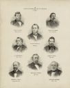
| Date: | 1878 |
|---|---|
| Description: | This print shows eight former Governors of Wisconsin. In date order: "Louis P. Harvey, 1862 til April 20"; "Edward Salomon, April 20 1862-1864"; "James T. ... |

| Date: | 1715 |
|---|---|
| Description: | A map of the countries and islands surrounding the Gulf of Mexico. The hand-colored borders separate the territories of England, France, Spain, and Holland... |

| Date: | 1739 |
|---|---|
| Description: | This map shows the territorial claims of the western hemisphere by the European powers, as well as the names of major cities, geographical features, and pa... |

| Date: | 1746 |
|---|---|
| Description: | A map of the western hemisphere, including parts of western Europe and Africa, showing the division of the Americas by the European powers. Weapons and fol... |

| Date: | 1720 |
|---|---|
| Description: | One of Herman Moll's most famous maps, often referred to as The Beaver Map for its elaborate engraved inset depicting and describing beavers building a dam... |

| Date: | 1715 |
|---|---|
| Description: | One of Herman Moll's most famous maps, often referred to as The Codfish Map, it shows rivers and portages, cities, Indian villages, wind directions, routes... |

| Date: | 1720 |
|---|---|
| Description: | This map of North America shows cities, rivers, lakes, and a few topographical features, complete with numerous descriptive blocks of text about expedition... |

| Date: | 1746 |
|---|---|
| Description: | Map of North America from the southern portion of James Bay to Florida. It shows the colonies, cities, Native American land, and topological and geographic... |

| Date: | 1758 |
|---|---|
| Description: | This map of the north-west hemisphere shows the cities, lakes, rivers, mountains, and political borders. In the upper left corner sits a decorative cartouc... |

| Date: | 1755 |
|---|---|
| Description: | This map shows forts, missions, villages and cities, rivers and portages, and boundaries of the Spanish, English, and French territories, marking the large... |

| Date: | 1757 |
|---|---|
| Description: | This map shows the cities, plantations, lakes, rivers, mountains, Native American territories and colonial borders of the Eastern half of North America, pl... |

| Date: | 1755 |
|---|---|
| Description: | This map shows the eastern half of North America during the French and Indian war, including cities, borders, Native American Land, forts, and detailed geo... |
If you didn't find the material you searched for, our Library Reference Staff can help.
Call our reference desk at 608-264-6535 or email us at: