Filter: Type of Map or Atlas
Filter: Subject of transportation
Filter: Type of Map or Atlas
Filter: Subject of transportation

| Date: | 1855 |
|---|---|
| Description: | Map of the city of Madison, Dane County, published by George Harrison, surveyed and drawn by P. McCabe, and engraved by J.H. Colton & Co., New York. In add... |

| Date: | 07 01 1836 |
|---|---|
| Description: | Original plat map of the town of Madison on the four lakes. |

| Date: | 1859 |
|---|---|
| Description: | Map featuring various views of buildings and scenes from Sauk County. |

| Date: | 1769 |
|---|---|
| Description: | Manuscript map. Scale: about 80 British statue miles to 1 inch. |

| Date: | 1670 |
|---|---|
| Description: | This map is in French and shows Lac Tracy ov Superieur (Lake Superior), Baye des Puans (Green Bay), and portions of Lac des Ilinois (Lake Michigan) and Lac... |

| Date: | 1776 |
|---|---|
| Description: | In French: "Partie Occidentale du Canada et septentrionale de la Louisiane avec une partie de la Pensilvanie." A map showing graticule and six European sca... |

| Date: | 1673 |
|---|---|
| Description: | P. Marquette en Joliet, gedan in't jaar 1673. |

| Date: | 1880 |
|---|---|
| Description: | This map shows railroads by operator and projected railroads. Portions of Lake Michigan, Lake Superior, Illinois, Iowa, Michigan and Minnesota are labeled. |

| Date: | 1857 |
|---|---|
| Description: | Information depicting the history, condition and prospects of the Indian tribes of the United States: collected and prepared under the direction of the Bur... |

| Date: | 1896 |
|---|---|
| Description: | Map showing the Wisconsin Central Railroad and its land grant, with the railroad and the land grant in color (red). |

| Date: | 1909 |
|---|---|
| Description: | [Lithography] by Poole Bros. Contains descriptive information. Short jaunts for busy people to nearby resorts in Illinois and Wisconsin. |

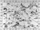
| Date: | 1939 |
|---|---|
| Description: | A color, pictorial map. Scale: 10 miles to the inch. Shows state parks and forests, proposed state parkways, proposed state monuments and memorials, nation... |

| Date: | 1918 |
|---|---|
| Description: | "The playground of the Middle West." Showing the Numbered and Marked State Trunk Highway System and the Principal Secondary Highways; also locates Points o... |

| Date: | |
|---|---|
| Description: | Plat map of the east central part of the city. |

| Date: | 1882 |
|---|---|
| Description: | This basic reference map of the state shows natural features, railroads, county seats, and political boundaries against the G.L.O. township and range grid.... |

| Date: | 1830 |
|---|---|
| Description: | A color map of the Michigan and Wisconsin territories with an inset showing the Ste. Marie River. |

| Date: | 1910 |
|---|---|
| Description: | Wisconsin Geological and Natural History Survey, by Lawrence Martin reproduced from a model of the state prepared by W.O. Hotchkiss and F.T. Thwaites and m... |
If you didn't find the material you searched for, our Library Reference Staff can help.
Call our reference desk at 608-264-6535 or email us at: