 Filter: Subject of battles
Filter: Subject of shorelines
Filter: Subject of battles
Filter: Subject of shorelines

| Date: | |
|---|---|
| Description: | Painting by Cal Peters depicting the battle of Bad Axe, also known as the Bad Axe massacre, at the Mississippi River on August 2, 1832. |

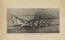
| Date: | 1852 |
|---|---|
| Description: | Illustration of the Ojibwa, the Sacs, and Foxes battling from canoes on the water. |

| Date: | 1943 |
|---|---|
| Description: | Treasury Design No. 26, "Invasion." The poster features ships landing on the coast and soldiers racing up the beach as explosions rain down around them. |
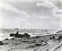
| Date: | 02 19 1945 |
|---|---|
| Description: | Marines on the beach and military boats, including an LSM 242, in the water at Iwo Jima. |
| Date: | |
|---|---|
| Description: | A halftone lithograph of the Battle of Grand Gulf, Mississippi. |

| Date: | |
|---|---|
| Description: | "Capture of Fort Fisher." A color lithograph published by L. Prang & Co., Boston. |

| Date: | 1862 |
|---|---|
| Description: | This map of the Mississippi River between Island No. 8, northeast of New Madrid, Missouri, and Tiptonville, Tennessee, depicts the Confederate defenses at ... |
| Date: | 12 26 1943 |
|---|---|
| Description: | Elevated view looking down towards deck of an American cruiser leaving the base heading for the bombardment of Cape Gloucester, New Britain, New Guinea (pr... |
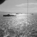
| Date: | 12 26 1943 |
|---|---|
| Description: | Elevated view, perhaps from an American Cruiser, of warships leaving the base heading for the bombardment of Cape Gloucester, New Britain, New Guinea (pres... |

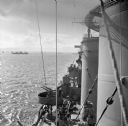
| Date: | 12 26 1943 |
|---|---|
| Description: | Seaman 2nd Class Jerry Burg (left) of Milwaukee, Wisconsin, and Seaman 2nd Class Harold Dawson of Toledo, Ohio, man the plane spotting station on an Americ... |
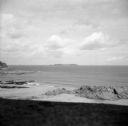
| Date: | 08 31 1944 |
|---|---|
| Description: | View from shoreline of Cezembre Island, just north of Saint-Malo on the north coast of France. It was German-occupied until the Allies mounted an operation... |

| Date: | 10 1776 |
|---|---|
| Description: | Broadside map showing the British invasion of New York city in August and September of 1776. The map shows important cities, forts, roads, hills, mountains... |

| Date: | 1781 |
|---|---|
| Description: | Map of the southern portion of the Chesapeake Bay and surrounding lands. It shows counties, a few cities and towns, forts, roads, islands, topographical fe... |

| Date: | 1609 |
|---|---|
| Description: | Illustration of an elevated view of a battle between Iroquois tribe and French on the banks of river. The Iroquois are unclothed and armed with bows and ar... |
If you didn't find the material you searched for, our Library Reference Staff can help.
Call our reference desk at 608-264-6535 or email us at: