 Filter: Subject of revolution, 1775-1783
Filter: Subject of transportation
Filter: Subject of revolution, 1775-1783
Filter: Subject of transportation

| Date: | 12 1952 |
|---|---|
| Description: | In Washington park, Washington Park library in the background. Nighttime view, with snow falling. The statue of Frederick Von Steuben on horseback preside... |

| Date: | |
|---|---|
| Description: | A road curves to the right and in the background is the Star Redoubt, a military structure built by Continental soldiers during the winter encampment of 17... |
| Date: | |
|---|---|
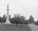
| Description: | Side view of the New Jersey Brigade Monument. Atop the monument stands a New Jersey Continental Soldier, and the base reads, "New Jersey Brigade," and "Con... |

| Date: | |
|---|---|
| Description: | Two statues mark the entrance of the picnic area of Valley Forge National Park. The monuments consist of identical bases and an eagle on top of each column... |

| Date: | |
|---|---|
| Description: | View of the Minuteman Statue in a park setting. The sculpture was completed in 1874 by Daniel Chester French. |

| Date: | 05 01 1899 |
|---|---|
| Description: | Map showing the Schuylkill River with roads, ferries, and points of interest from Valley Forge to Philadelphia, Pennsylvania as it appeared during the Revo... |

| Date: | 1776 |
|---|---|
| Description: | This was one of the first maps available for the general British populace featuring America during the Revolutionary War. It includes forts, cities, topogr... |

| Date: | 1783 |
|---|---|
| Description: | This map is hand-colored and shows the boundaries of British, Spanish, and the newly recognized American claims, as well as the fishing rights granted to F... |

| Date: | 1776 |
|---|---|
| Description: | Map of the American colonies and land east of the Mississippi River. Prominent cities, forts, Native American land, mountains, rivers and lakes are all sho... |

| Date: | 1782 |
|---|---|
| Description: | Map of America east of the Mississippi River. It shows regions, state boundaries extending to the Mississippi River, cities, forts, Native American lands, ... |

| Date: | 1780 |
|---|---|
| Description: | Detailed map of America east of the Louisiana region. It shows forts, cities, borders and boundary lines, Native American land, the post road, mountains, w... |

| Date: | 1775 |
|---|---|
| Description: | Map of Boston and surrounding regions, from Massachusetts Bay to the Connecticut River, and including part of southern New Hampshire. It shows the colonies... |

| Date: | 1780 |
|---|---|
| Description: | Detailed topographical and political map of the area from Lake Champlain to Albany and the Hudson River. Relief is shown through hachures. The map shows ci... |

| Date: | 1795 |
|---|---|
| Description: | Detailed map of New York, showing counties, cities, mines, mills, roads, swamps, mountains, lakes and rivers. The map also shows Native American towns and ... |

| Date: | 1778 |
|---|---|
| Description: | Map of the land between Fort Ticonderoga and Albany. It shows cities, forts, mills, roads, mountains, swamps, waterfalls, lakes, and rivers. A few annotati... |

| Date: | 10 1776 |
|---|---|
| Description: | Broadside map showing the British invasion of New York city in August and September of 1776. The map shows important cities, forts, roads, hills, mountains... |

| Date: | 02 1777 |
|---|---|
| Description: | Map depicting the campaigns of October and November 1776, in Manhattan, Westchester, and part of New Jersey, published only a few months after the conclusi... |

| Date: | 03 1777 |
|---|---|
| Description: | Map showing the British and Hessian attack on Fort Washington in November of 1776. The movements and fortifications of the British and Hessian troops appea... |

| Date: | 11 1781 |
|---|---|
| Description: | Map of New York, Staten Island, and Long Island, showing the placements of forts, and the movement of troops in 1776. The map also includes towns, cities, ... |

| Date: | 1776 |
|---|---|
| Description: | Fairly detailed map of New York City and parts of Long Island. It shows streets, roads, wharves, ferries, ship yards, Fort George and the battery, public b... |
If you didn't find the material you searched for, our Library Reference Staff can help.
Call our reference desk at 608-264-6535 or email us at: