 Search: grants
Filter: Subject of water
Search: grants
Filter: Subject of water

| Date: | 1875 |
|---|---|
| Description: | A hand-drawn and colored map of Wisconsin showing the railroad routs and railroad land grants La Cross and Milwaukee Railroad, St. Croix and Tomah Railroad... |

| Date: | 1856 |
|---|---|
| Description: | A map showing rail lines in Wisconsin and the railroad land grants of the Superior & St. Croix Railroad in the present-day northwestern Wisconsin counties ... |

| Date: | 1880 |
|---|---|
| Description: | This map covers parts of Minnesota, Iowa, and South Dakota and advertised 1,000,000 acres of land available. Communities, roads, and railroad lines are lab... |

| Date: | 1776 |
|---|---|
| Description: | Map of New Jersey and New York, showing cities, forts, roads, counties, townships, land grants, rivers, lakes and several topographical features. Much of t... |

| Date: | 1906 |
|---|---|
| Description: | An Apache man standing by the edge of a pool of water. |

| Date: | 1896 |
|---|---|
| Description: | A map showing the Wisconsin Central Railroad lines in Wisconsin, northern Illinois, eastern Minnesota, and Michigan’s Upper Peninsula. The area of the map ... |

| Date: | 1910 |
|---|---|
| Description: | American Indians sitting near dwellings at the edge of a body of water. |
| Date: | 1910 |
|---|---|
| Description: | The original caption reads: "The Chinookan tribes on the Columbia obtained their canoes for the greater part from the coast tribes of Washington. The woman... |
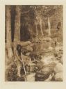
| Date: | 1923 |
|---|---|
| Description: | The original caption reads: "A Hupa youth is waiting with poised spear for the shadowy outline of a salmon lurking in a quiet pool and gathering its streng... |

| Date: | 1758 |
|---|---|
| Description: | This map of the north-west hemisphere shows the cities, lakes, rivers, mountains, and political borders. In the upper left corner sits a decorative cartouc... |

| Date: | 1910 |
|---|---|
| Description: | The original caption reads: "The Kalispel, who now number about a hundred, are scattered along the eastern side of the Pend d'Oreille river in eastern Wash... |

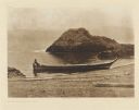
| Date: | 1910 |
|---|---|
| Description: | The original caption reads: "Spokane river, from a short distance below its head in Coeur d'Alene lake to its confluence with the Columbia, flows through t... |
If you didn't find the material you searched for, our Library Reference Staff can help.
Call our reference desk at 608-264-6535 or email us at: