 Search: indians
Filter: Type of Map or Atlas
Search: indians
Filter: Type of Map or Atlas

| Date: | 1857 |
|---|---|
| Description: | A map of the state of Wisconsin and the southeastern portion of the Territory of Minnesota, showing the Wisconsin reservations of the Oneida, Menominee, St... |

| Date: | 1930 |
|---|---|
| Description: | This map shows rivers, lakes, trails, Indian villages, distances, and boundaries of tracts ceded by the Munnomonee, Winnebaygoes, and New York Indians Trib... |

| Date: | 1836 |
|---|---|
| Description: | This negative photostat map shows the "oak tree, place of beginning" on the division line between Stockbridge and Brothertown Indians, and Governor Porter'... |

| Date: | 1858 |
|---|---|
| Description: | A survey map that shows the status of township surveys in Wisconsin. At that point, the majority of the state had been surveyed and platted, with the area... |
| Date: | 1905 |
|---|---|
| Description: | A reproduction of the Wisconsin portion of Samuel de Champlain's 1632 map showing the location of the La Nation du Puans, or Ho-Chunk Indians, located next... |
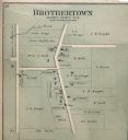
| Date: | 1893 |
|---|---|
| Description: | Plat map of Brothertown in Calumet County. |

| Date: | 1795 |
|---|---|
| Description: | Map of Georgia, with its borders extending to the Mississippi River. It shows borders, various boundary lines, counties, cities, towns, Native American lan... |

| Date: | 1962 |
|---|---|
| Description: | A map showing the location of Indian settlements in Wisconsin, indicating the settlements of the Chippewa, or Ojibwe, at St. Croix, Lac Courte Oreilles, Re... |

| Date: | 1837 |
|---|---|
| Description: | This map shows planned military posts/depots, barracks, rivers, lakes, roads, existing forts, and land assigned to various Indian tribes. Arkansas, Illinoi... |

| Date: | 1938 |
|---|---|
| Description: | This map shows lakes, rivers, roads, trails, lookout towers, and railroads. |

| Date: | 1959 |
|---|---|
| Description: | An illustrated map showing American Indian communities in the United States. |

| Date: | 1979 |
|---|---|
| Description: | A map of Southern Wisconsin and northern Illinois showing the areas inhabited by the Ho-Chuck, formerly known as the Winnebago. Some of the location names ... |

| Date: | 1777 |
|---|---|
| Description: | This detailed map of the American colonies shows cities, villages, roads, mountains, lakes, rivers, swamps, counties, state boundaries, and Native American... |

| Date: | 1860 |
|---|---|
| Description: | A survey map of Wisconsin, southeastern Minnesota, and northern Iowa, showing the status of surveys, rivers, and lakes. The map also shows the locations of... |

| Date: | 1877 |
|---|---|
| Description: | Map showing location of Indian reservations in the United States and population figures. |

| Date: | 1900 |
|---|---|
| Description: | This photostatic map shows landownership and acreages in parts of T22-24N, R18-20E. |

| Date: | 1857 |
|---|---|
| Description: | This map depicts the township survey grid and identifies counties, named towns, cities and villages, rivers, lakes, railroads, roads, and the Menomonee and... |

| Date: | 1858 |
|---|---|
| Description: | This map of the entire state of Wisconsin depicts the township survey grid and identifies counties, named towns, cities and villages, rivers, lakes, railro... |

| Date: | 1878 |
|---|---|
| Description: | A hand-colored, cloth mounted, sectional map of Wisconsin and the western portion of Michigan’s Upper Peninsula, showing the township grid, railroads, town... |

| Date: | 1756 |
|---|---|
| Description: | Map of Pennsylvania, showing cities, towns, roads, trading paths, portages, forts, mountains, swamps, waterfalls, lakes, and rivers. The map further includ... |
If you didn't find the material you searched for, our Library Reference Staff can help.
Call our reference desk at 608-264-6535 or email us at: