 Search: menominee

| Date: | 1975 |
|---|---|
| Description: | Actor Marlon Brando (center) and Father James Groppi of Milwaukee arrive at the Alexian Novitiate in Gresham. The building had been seized by members of th... |

| Date: | 1846 |
|---|---|
| Description: | A map of Wisconsin and a portion of Minnesota that show the township surveys in progress in portions of the Saint Croix River region and in central Wiscons... |

| Date: | 1848 |
|---|---|
| Description: | Map of Wisconsin and a portion of Minnesota showing the township surveys in progress in portions of the Saint Croix River region and in central Wisconsin a... |

| Date: | 1921-05-22 |
|---|---|
| County: | Dane |
| City: | Madison |
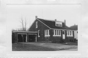
| Community: | Aurora |
|---|---|
| County: | Florence |
| Historic Name: | |
| Reference Number: | 22361 |

| Date: | 07 26 1931 |
|---|---|
| Description: | An elevated view of the Wolf River. The base of Smokey Falls is in the foreground. A large pine is growing on the rocky bank on the right. The printed capt... |
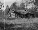
| Date: | 09 17 1961 |
|---|---|
| Description: | A broken down, abandoned log shack on the Stockbridge Indian Reservation. |
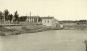
| Date: | 1887 |
|---|---|
| Description: | View of the boom company office and the site of the old trading post. |

| Date: | 1887 |
|---|---|
| Description: | Mill workers in the yard at Ramsay & Jones Mill. |

| The Changing Status of the Native Americans |
|---|
| Read about Wisconsin's Indian tribes and their changing legal status throughout the 20th century. |
| Date: | 1923-08-29 |
|---|---|
| County: | Fond Du Lac |
| City: | North Fond du Lac |
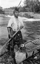
| Date: | 1925 |
|---|---|
| Description: | A portrait of a descendant of Chief Oshkosh, probably Ernest Oshkosh, with one foot in a traditional canoe. This image is part of an exhibit about Native A... |
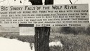
| Date: | 1920 |
|---|---|
| Description: | Sign for the toll road at Big Smoky Falls on the Wolf River. The sign reads: "Big Smoky Falls of the Wolf River. Many years ago before 1925 there was no ro... |
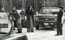
| Date: | 1975 |
|---|---|
| Description: | An unidentified member of the Wisconsin State Patrol points his revolver at several Native Americans at a vehicle checkpoint near Gresham. The State Patrol... |

| Date: | 1979 |
|---|---|
| Description: | A map of Southern Wisconsin and northern Illinois showing the areas inhabited by the Ho-Chuck, formerly known as the Winnebago. Some of the location names ... |
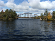
| Community: | Florence |
|---|---|
| County: | Florence |
| Historic Name: | Upper Twin Falls Bridge |
| Reference Number: | 12001028 |

| Date: | 1887 |
|---|---|
| Description: | The Ramsay & Jones Mill with logs in the water in the foreground. |

| Date: | 1855 |
|---|---|
| Description: | This Wisconsin map depicts counties, creeks, rivers, lakes, railroads completed, railroads in progress, common roads and the Menomonee Reservation. |
If you didn't find the material you searched for, our Library Reference Staff can help.
Call our reference desk at 608-264-6535 or email us at:
