 Search: mounds
Filter: Categories of Wisconsin Historical Images
Filter: Year of 1800-1899
Search: mounds
Filter: Categories of Wisconsin Historical Images
Filter: Year of 1800-1899
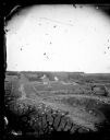
| Date: | 1873 |
|---|---|
| Description: | View down a rocky rural lane near West Blue Mounds. Zigzag stake and rider split-rail fencing enclose a farmstead, which includes a barn, a frame house, ha... |

| Date: | 08 30 1876 |
|---|---|
| Description: | "View of the ministers present" from the "Dedication of Blue Mounds Church" section of Dahl's 1877 "Catalogue of Stereoscopic Views." The congregation of t... |

| Date: | 1866 |
|---|---|
| Description: | A map of Lafayette County, Wisconsin, showing the townships and ranges, sections, towns, villages, stream and rivers, mounds, mineral deposits and the Mine... |
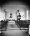
| Date: | 08 30 1876 |
|---|---|
| Description: | "View of the interior of the church" from the "Dedication of Blue Mounds Church" section of Dahl's 1877 "Catalogue of Stereoscopic Views." The church was d... |

| Date: | 1864 |
|---|---|
| Description: | This map is pen and pencil on paper and shows a profile of the Blue Mound and East Blue Mound. |
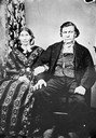
| Date: | 1876 |
|---|---|
| Description: | Half of a double portrait of Ever or Iver B. Lund and wife, of Blue Mounds, Blue Valley. He was a tailor by trade. Note his withered left leg. |

| Date: | 1864 |
|---|---|
| Description: | This map is pen and watercolor on paper and shows a profile and geological sections of the Blue Mounds, Hollow Run, Bogies Hollow Run, Bear Creek, East Bre... |

| Date: | 1864 |
|---|---|
| Description: | This map is pen and watercolor on paper and shows profile and geological formation of Blue Mound and location of Arnold’s Hotel and Brigham Lead Mines. |
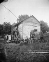
| Date: | 1871 |
|---|---|
| Description: | Andrew Dahl's wagon is on the side of a two-story log house in Blue Mounds. On one side of the wagon cover is "A.L. Dahl Landscape Photographer." On the ba... |
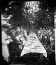
| Date: | 1876 |
|---|---|
| Description: | "View of the Dining Table" from the "Dedication of Blue Mounds Church" section of Dahl's 1877 "Catalogue of Stereoscopic Views", showing a long banquet tab... |

| Date: | 1892 |
|---|---|
| Description: | This map oriented with north to the upper left shows railroads, creeks, post offices, smaller lakes, Lake Mendota, Lake Monona, Lake Wingra, Lake Waubesa, ... |
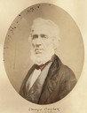
| Date: | 1856 |
|---|---|
| Description: | Quarter-length oval portrait of Ebenezer Brigham, founder of the first major community in the Blue Mounds of Wisconsin, which included a mine, frontier inn... |
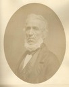
| Date: | 1856 |
|---|---|
| Description: | Quarter-length oval portrait of Ebenezer Brigham, founder of the first major community in the Blue Mounds of Wisconsin, which included a mine, frontier inn... |

| Date: | 1850 |
|---|---|
| Description: | Map showing Indian mounds and graves as well as ground cover types at Township 8, Range 22. There is an inset diagram of an effigy mound labeled "The Cross... |

| Date: | 1840 |
|---|---|
| Description: | This map shows local streets, numbered lots, and part of Blue Mounds Branch. The map reads: "NE 1/4 NW 1/4 Sect. 16 - T5 - R5E." under the title and is dat... |

| Date: | 1861 |
|---|---|
| Description: | This map shows townships and sections, landownership, roads, railroads, rural residences, schools, churches, and topography. Also included are inset maps o... |
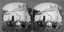
| Date: | 1875 |
|---|---|
| Description: | A family group of eleven sits around a table with a pitcher and books before the farm house of Knud Gjesma. |

| Date: | 1892 |
|---|---|
| Description: | Topographical map of Madison and surrounding communities which include Lake Mendota, Lake Monona, Lake Waubesa and Lake Kegonsa. The red dots on the map sh... |

| Date: | 1849 |
|---|---|
| Description: | Published in Germany a year after Wisconsin entered statehood, this map shows prairies, swamps, lakes, mounds, limestone deposits, and lead and copper mine... |

| Date: | 1864 |
|---|---|
| Description: | This map is pen and pencil on paper and shows a profile of the Blue Mound and East Blue Mound. |
If you didn't find the material you searched for, our Library Reference Staff can help.
Call our reference desk at 608-264-6535 or email us at: