 Filter: Categories of Wisconsin Historical Images
Filter: Subject of Periodicals
Filter: Subject of arts
Filter: Categories of Wisconsin Historical Images
Filter: Subject of Periodicals
Filter: Subject of arts

| Date: | 02 1954 |
|---|---|
| Description: | Edward D. Hollander, national director of Americans for Democratic Action, refers to a chart with the title, "Doom and Gloom — Look who's talking". |

| Date: | |
|---|---|
| Description: | Front porch at Modern Home Hotel. There is a drinking fountain in the foreground on the left. The furniture on the porch includes a desk, rocking chairs, a... |

| Date: | 1905 |
|---|---|
| Description: | A young woman, Jessie Underwood, reclining supported on one elbow on a fur rug in front of a piano. In front of her lying on the rug is a cat. Light comes ... |

| Date: | 1780 |
|---|---|
| Description: | This map portrays North and South America at a very unusual angle, with north oriented towards the upper right corner. Colonies, Native American land, a fe... |

| Date: | 1758 |
|---|---|
| Description: | Map showing lakes, rivers, cities, Native American land, and the boundaries of French and English claims in America and Canada north of New York. A title c... |

| Date: | 1762 |
|---|---|
| Description: | Map including the land and islands surrounding the Gulf of Mexico. The regions and islands are labeled, as are a few rivers and cities. This map was engrav... |

| Date: | 1763 |
|---|---|
| Description: | Map of America and part of Canada including the borders of European claims after the French and Indian War. Cities, forts, Native American lands, rivers, l... |

| Date: | 1776 |
|---|---|
| Description: | Map of the American colonies and land east of the Mississippi River. Prominent cities, forts, Native American land, mountains, rivers and lakes are all sho... |

| Date: | 02 1783 |
|---|---|
| Description: | Map of the United States and one of the first to show the new boundaries created by the Preliminary Treaty signed on January 20, 1783. The former colonies ... |

| Date: | 1765 |
|---|---|
| Description: | Detailed map composed for the London Magazine of the Mississippi River Valley at the conclusion of the French and Indian War. The British colonies themselv... |

| Date: | 1755 |
|---|---|
| Description: | Map of New England, with three inset maps of Fort Oswego, Fort du Quesne, and Fort Frederick. It shows colonies, a few cities, forts (marked as French or E... |

| Date: | 1775 |
|---|---|
| Description: | Map of Boston and surrounding regions, from Massachusetts Bay to the Connecticut River, and including part of southern New Hampshire. It shows the colonies... |

| Date: | 1675 |
|---|---|
| Description: | Map of the southeast coast of North America from Jamestown to modern Georgia. It shows European settlements, Native American land and villages, coastal fea... |

| Date: | 1762 |
|---|---|
| Description: | Map of Virginia and parts of Maryland. It shows borders, boundary lines, Native American tribes and land, towns, forts, roads, mountains, waterfalls, bays,... |

| Date: | 1781 |
|---|---|
| Description: | Map of the southern portion of the Chesapeake Bay and surrounding lands. It shows counties, a few cities and towns, forts, roads, islands, topographical fe... |

| Date: | 1760 |
|---|---|
| Description: | Map showing the towns, mountains, valleys, corn fields, and rivers of a portion of the Cherokee Nation. A few annotations on the map explain the land and r... |

| Date: | 1781 |
|---|---|
| Description: | Map of the British territory of West Florida, extending from the Mississippi River to the Apalachicola River. It shows the borders, cities, towns, forts, h... |
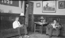
| Date: | 05 1936 |
|---|---|
| Description: | Herbert E. Brumder, left, and an unidentified young man are sitting and reading in a dormitory parlor. Coats are hanging on the back of a door at center. T... |

| Date: | 05 1971 |
|---|---|
| Description: | Front cover of Scarlet Letter newsletter, volume 1, number 1. The cover features a drawn portrait of a woman, signed "Sis." |

| Date: | 01 02 1962 |
|---|---|
| Description: | Portrait of Charles & Victoria Slayton, parents of astronaut Donald "Deke" Slayton, sitting in their home in Leon, Wisconsin with framed photographs of the... |
If you didn't find the material you searched for, our Library Reference Staff can help.
Call our reference desk at 608-264-6535 or email us at: