 Filter: Categories of Wisconsin Historical Images
Filter: Subject of Periodicals
Filter: Reproduction Rights of For Sale
Filter: Categories of Wisconsin Historical Images
Filter: Subject of Periodicals
Filter: Reproduction Rights of For Sale

| Date: | 1762 |
|---|---|
| Description: | Map including the land and islands surrounding the Gulf of Mexico. The regions and islands are labeled, as are a few rivers and cities. This map was engrav... |

| Date: | 1763 |
|---|---|
| Description: | Map of America and part of Canada including the borders of European claims after the French and Indian War. Cities, forts, Native American lands, rivers, l... |

| Date: | 1776 |
|---|---|
| Description: | Map of the American colonies and land east of the Mississippi River. Prominent cities, forts, Native American land, mountains, rivers and lakes are all sho... |

| Date: | 02 1783 |
|---|---|
| Description: | Map of the United States and one of the first to show the new boundaries created by the Preliminary Treaty signed on January 20, 1783. The former colonies ... |

| Date: | 1765 |
|---|---|
| Description: | Detailed map composed for the London Magazine of the Mississippi River Valley at the conclusion of the French and Indian War. The British colonies themselv... |

| Date: | 1755 |
|---|---|
| Description: | Map of New England, with three inset maps of Fort Oswego, Fort du Quesne, and Fort Frederick. It shows colonies, a few cities, forts (marked as French or E... |

| Date: | 1775 |
|---|---|
| Description: | Map of Boston and surrounding regions, from Massachusetts Bay to the Connecticut River, and including part of southern New Hampshire. It shows the colonies... |

| Date: | 1675 |
|---|---|
| Description: | Map of the southeast coast of North America from Jamestown to modern Georgia. It shows European settlements, Native American land and villages, coastal fea... |

| Date: | 1762 |
|---|---|
| Description: | Map of Virginia and parts of Maryland. It shows borders, boundary lines, Native American tribes and land, towns, forts, roads, mountains, waterfalls, bays,... |

| Date: | 1781 |
|---|---|
| Description: | Map of the southern portion of the Chesapeake Bay and surrounding lands. It shows counties, a few cities and towns, forts, roads, islands, topographical fe... |

| Date: | 1760 |
|---|---|
| Description: | Map showing the towns, mountains, valleys, corn fields, and rivers of a portion of the Cherokee Nation. A few annotations on the map explain the land and r... |

| Date: | 1781 |
|---|---|
| Description: | Map of the British territory of West Florida, extending from the Mississippi River to the Apalachicola River. It shows the borders, cities, towns, forts, h... |

| Date: | 1918 |
|---|---|
| Description: | Several boys are posing with stacks of bound periodicals. An American flag is in the foreground. Caption reads: "Boys of Riverside High School, Milwaukee, ... |

| Date: | 01 28 1954 |
|---|---|
| Description: | A girl is sitting and working with material in the reference room of the Madison Free Library at 206 North Carroll Street. |
| Date: | 02 18 1954 |
|---|---|
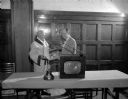
| Description: | John Walsh, University of Wisconsin boxing coach, is showing an issue of Esquire magazine to General Olson at a Rotary Club meeting. The February is... |

| Date: | 03 16 1954 |
|---|---|
| Description: | Magazine and newspaper rack at the Rennebohm Drug Store #16 at 2801 East Washington Avenue. |
| Date: | 08 06 1954 |
|---|---|
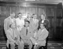
| Description: | Group portrait of eight men at a meeting of Madison Newspapers, Inc., the publisher of the Madison State Journal and Capitol Times. |

| Date: | 03 25 1955 |
|---|---|
| Description: | Morris Rubin, editor of The Progressive, sitting at his desk decked with a glass ashtray with cigarette, matchbook, and papers. In 1940, Rubin (b.19... |

| Date: | 12 1954 |
|---|---|
| Description: | The first page of an article published in The Westerner, a publication for the employees of the Western Printing & Lithographing Company of Racine. ... |

| Date: | 12 1954 |
|---|---|
| Description: | The second page of an article published in The Westerner, a publication for the employees of the Western Printing & Lithographing Company of Racine.... |
If you didn't find the material you searched for, our Library Reference Staff can help.
Call our reference desk at 608-264-6535 or email us at: